The Historic Columbia River Highway_
The Historic Columbia River Highway, built in the early 1900s, was America’s first planned scenic roadway and was designed to showcase the Gorge’s waterfalls, cliffs, and sweeping river views. Today, restored segments and the Historic Columbia River Highway State Trail let visitors experience its iconic stonework, viewpoints, and classic Pacific Northwest scenery at a slower pace.
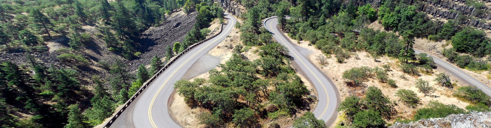
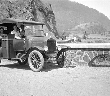
Winding through one of the most breathtaking landscapes in North America, the Historic Columbia River Highway represents far more than a transportation corridor—it stands as a testament to human ingenuity, artistic vision, and the early conservation movement. Carved into the basalt cliffs of the Columbia River Gorge between 1913 and 1922, this remarkable roadway became the first planned scenic highway constructed in the United States.
Often called the "King of Roads," this engineering marvel stretches approximately 73 miles from Troutdale, just east of Portland, to The Dalles. Unlike modern highways designed purely for efficient travel, this route was conceived with a singular philosophy: to showcase every waterfall, viewpoint, and natural wonder while leaving the landscape as undisturbed as possible.
Today, the highway continues to captivate visitors with its graceful stone masonry, elegant bridges, and panoramic vistas that have remained virtually unchanged for over a century.


A Road Through Time
The Visionaries
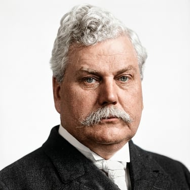
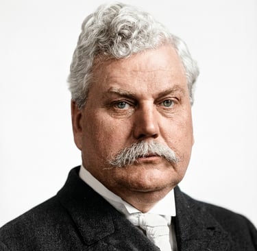
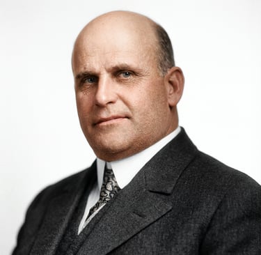
Samuel Hill
GOOD ROADS PROMOTER & VISIONARY
A wealthy entrepreneur, railroad lawyer, and passionate advocate for quality roads, Samuel Hill dreamed of a scenic highway that would rival the great mountain roads of Europe. After visiting Switzerland's Axenstrasse in 1908, he became obsessed with creating something equally magnificent in the Pacific Northwest. Hill convinced the Oregon legislature to establish the State Highway Commission in 1913 and was instrumental in making his vision a reality. He also built the experimental Maryhill Loops Road as a proof of concept, demonstrating that graceful curves could overcome steep terrain.
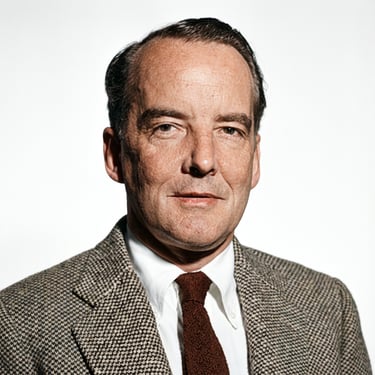
Samuel C. Lancaster
CHIEF ENGINEER & LANDSCAPE ARCHITECT
The creative genius behind the highway's design, Samuel Lancaster approached road-building as an art form. His philosophy centered on finding the "beauty spots" first, then designing the road to reach them without marring the landscape. Lancaster studied European mountain highways, then adapted their techniques for the challenging terrain of the Columbia River Gorge. He brought Italian stone masons from Europe to construct the elegant bridges and retaining walls that remain beloved today. His famous quote captured his vision: "God put these things here for people to enjoy, and it was up to me not to mar what God had put there."
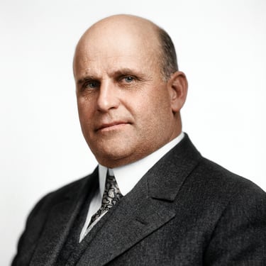
John B. Yeon
MULTNOMAH COUNTY ROADMASTER
A retired lumber baron who served as Multnomah County Roadmaster, John B. Yeon oversaw the daily construction of the highway's western section. He volunteered his services without pay, driven by civic pride and a genuine love for the Gorge. Yeon supervised the skilled craftsmen who built the highway's distinctive stonework, viaducts, and bridges. He also oversaw construction of the Vista House at Crown Point, ensuring it met the highest standards of quality and aesthetics.
Simon Benson
PHILANTHROPIST & CONSERVATIONIST
A retired lumber magnate and hotelier, Simon Benson played a crucial role in preserving the Gorge's natural beauty for future generations. He purchased numerous scenic sites along the highway alignment—including Multnomah Falls—and donated them to the state to be protected as public parks. Benson also provided critical financial support for the highway project, including purchasing an entire bond issue to fund construction. The iconic Benson Bridge at Multnomah Falls bears his name today.


Engineering Marvel
Building a scenic highway through the rugged Columbia River Gorge required innovations that influenced road design across America. Here's what made it possible:
Stone Masonry
Italian craftsmen brought from Europe constructed the highway's distinctive dry-laid and mortared stone walls. These retaining walls hold the roadway against steep hillsides, while elegant guard walls protect travelers from precipitous drops—all without visual intrusion on the natural landscape.
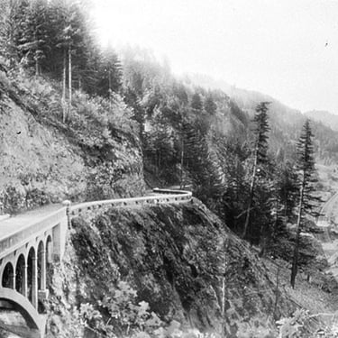
Viaducts & Half-Viaducts
Where terrain made conventional road-building impossible, engineers constructed viaducts—elevated structures that carried the highway along cliff faces with minimal disturbance. Half-viaducts, anchored directly into hillsides, often escaped motorists' notice entirely, creating the illusion of a normal roadway.
Strict Grade Standards
Despite traversing from river level to cliff-top heights, the highway maintains maximum grades of only 5 percent and minimum curve radii of 100 feet—gentle enough for the early automobiles of the era. Where steep terrain demanded, engineers "developed distance" through elegant loops.
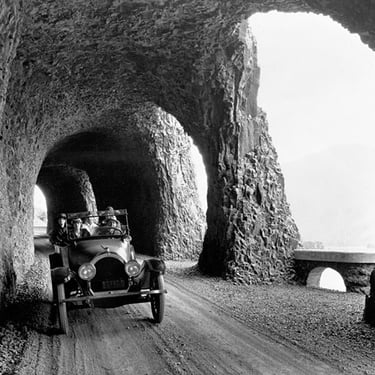
Windowed Tunnels
Inspired by Switzerland's Axenstrasse, engineers carved tunnels through solid basalt and then cut viewing windows into the cliff face—transforming necessary infrastructure into scenic attractions. These engineering feats became some of the highway's most celebrated features.
Reinforced Concrete Bridges
Eleven major bridges spanning streams and ravines combined the strength of reinforced concrete with the beauty of stone masonry railings and arched designs. Each bridge was conceived as an artistic complement to its surroundings rather than a merely functional crossing.
Advanced Drainage
Lancaster designed a comprehensive drainage system borrowed from city streets: raised road crowns, concrete curbs and gutters, and culverts for heavy water flow. This innovative approach prevented the erosion and flooding that plagued other mountain roads of the era.
The Journey to Restoration
When Interstate 84 was constructed through the Columbia River Gorge in the 1950s and 1960s, much of the original Historic Columbia River Highway was damaged, bypassed, or outright destroyed. Beloved features like the Mitchell Point Tunnel were demolished. Other sections were buried under the new interstate, abandoned, or left to decay under blankets of moss.
In 1986, Congress passed the Columbia River Gorge National Scenic Area Act, which included a mandate for the Oregon Department of Transportation to restore and reconnect the historic highway as a recreational facility. What began as a modest $2 million initial allocation has grown into a decades-long, multi-agency partnership involving ODOT, Oregon State Parks, the U.S. Forest Service, and dedicated advocacy groups.
The vision is ambitious: reconnect all 73 miles of the original route as a "world-class bicycle and pedestrian experience," with a mix of car-free paths and low-volume shared roads. Abandoned sections are being transformed into the Historic Columbia River Highway State Trail, allowing hikers and cyclists to experience the route as Samuel Lancaster intended—at a pace that allows for "silent communion with the infinite."
The restoration effort has achieved remarkable success, with only about 1.6 miles remaining to complete the full 73-mile connection. When finished, visitors will be able to travel from Troutdale to The Dalles along one continuous corridor, experiencing spectacular waterfalls, restored tunnels, historic viaducts, and the same breathtaking views that captivated early motorists over a century ago.
The Waterfall Corridor
The ten-mile stretch between Crown Point and Dodson represents one of the most remarkable concentrations of waterfalls found anywhere in North America. Fed by streams flowing off the steep volcanic cliffs of the Gorge's south side, dozens of cascades tumble from heights ranging from under a hundred feet to well over six hundred, creating a seemingly endless procession of falling water along this section of the Historic Columbia River Highway.
The abundance of waterfalls here owes much to the region's unique geology and climate. The towering basalt cliffs that line the Gorge were carved by the catastrophic Missoula Floods at the end of the last Ice Age, leaving behind sheer walls hundreds of feet high. Streams flowing from the plateau above have no choice but to plunge over these precipices. Meanwhile, the western Gorge receives substantial rainfall—often over 70 inches annually—ensuring that these falls run year-round, though they reach their most dramatic flows during winter and spring.
Samuel Lancaster designed the highway specifically to showcase these natural wonders. Rather than simply cutting the most efficient route through the landscape, he routed the road to pass directly beneath cascades, across elegant stone bridges spanning their creeks, and through pullouts positioned for optimal viewing. Many of the falls are visible directly from the car, while short accessible trails lead to the bases of others. The result is a driving experience unlike any other in the country, where waterfalls appear around nearly every bend in the road.
The corridor's most famous resident, Multnomah Falls, draws over two million visitors annually and ranks among the most photographed locations in the Pacific Northwest. But the true magic of the waterfall corridor lies in the cumulative experience—the sense of moving through a landscape where water, stone, and lush green forest combine at every turn to create scenes of extraordinary beauty.
Iconic Landmarks
Vista House at Crown Point
National Natural Landmark since 1971Perched 733 feet above the Columbia River on a dramatic basalt promontory, Vista House stands as the crown jewel of the Historic Columbia River Highway. This striking octagonal observatory was designed by architect Edgar Lazarus in the German Art Nouveau style and completed in 1918.
Built as both a "comfort station" for travelers and a memorial to Oregon pioneers, Vista House features sandstone exteriors, Alaskan Tokeen marble interiors, and opalized glass windows that glow when struck by sunlight. Samuel Lancaster envisioned it as a place where visitors could view the Columbia "in silent communion with the infinite."
The building underwent a comprehensive five-year restoration beginning in 2000 and today welcomes approximately one million visitors annually. The panoramic views from its observation deck encompass the Gorge in both directions, with Beacon Rock visible to the east and Portland on clear days to the west.
Rowena Crest & The Rowena Loops
Featured in numerous automobile commercialsRising 747 feet above the Columbia River near Mosier, Rowena Crest offers one of the most spectacular viewpoints along the entire highway. But the true engineering marvel lies below: the famous Rowena Loops, a series of elegant horseshoe curves that carry the road up from the river in graceful S-turns along the cliff face.
Engineer John A. Elliott designed these loops to maintain the highway's strict standards—maximum grades of 5 percent and minimum turning radii of 100 feet—while conquering seemingly impossible terrain. Rather than cutting straight up the steep hillside, the road "develops distance" by looping back and forth, creating one of the most photographed stretches of highway in Oregon.
The viewpoint at Rowena Crest also serves as a gateway to the Tom McCall Nature Preserve, famous for spectacular spring wildflower displays. Here, the Gorge transitions from the lush, mossy forests of the west to the semi-arid plateau of the east, offering a dramatic lesson in Pacific Northwest ecology.
Mitchell Point Tunnel
Reconstructed tunnel opened March 2025The original Mitchell Point Tunnel, completed in 1915, was one of the most beloved features of the historic highway. Inspired by Switzerland's Axenstrasse, engineer John A. Elliott designed a 390-foot tunnel through solid basalt with five arched windows offering breathtaking views of the Columbia River below. It was one of the first major roadway tunnels built in the United States.
Tragically, the original tunnel was demolished in 1966 to make room for Interstate 84. For decades, it seemed this engineering marvel was lost forever.
In 2021, ODOT broke ground on a reconstruction project to build a new tunnel at Mitchell Point as part of the Historic Highway State Trail. The 655-foot replica features five arched windows reminiscent of the original, hand-placed stone masonry, and stunning river views. After years of construction through challenging terrain, the new Mitchell Point Tunnel opened to pedestrians and cyclists in March 2025, allowing visitors to experience this iconic feature for the first time in over 70 years.
Mosier Twin Tunnels
4.5-mile car-free trail segmentBetween Hood River and Mosier, two tunnels were carved through a basalt hillside in 1920 to complete the eastern section of the highway. The eastern tunnel features two viewing windows, similar in design to the original Mitchell Point Tunnel, offering glimpses of the Columbia River below.
When Interstate 84 was constructed in the 1950s and 1960s, the tunnels were abandoned and filled with rock. They sat dormant for decades until a massive restoration project in the 1990s excavated them and restored this stretch as a car-free trail.
When workers removed the rock fill, they discovered surprises preserved inside—including historical graffiti dating to 1921, when travelers became snowbound here for several days. The Mosier Twin Tunnels reopened in 2000 and today form the centerpiece of a popular 4.5-mile trail connecting Hood River and Mosier, offering hikers and cyclists a unique window into the highway's golden age.
Fascinating Facts
First of Its Kind
The Historic Columbia River Highway was the first planned scenic roadway constructed in the United States, predating the National Park Service's scenic road program that it would later inspire.Multiple Designations
The highway holds an extraordinary collection of honors: National Register of Historic Places (1983), National Historic Landmark (2000), National Historic Civil Engineering Landmark, and All-American Road designation.Cost Comparison
The Oregon Highway Commission reported at the time that the Columbia River Highway was "probably the most difficult and costly priced highway construction undertaken in America," with total costs estimated at $11 million in 1920s dollars.European Craftsmen
Samuel Lancaster brought Italian stone masons from Europe specifically to construct the highway's elegant masonry walls, bridges, and guard rails—craftsmanship that has endured for over a century.Warrenite Pavement
The highway was surfaced with Warrenite, a patented asphaltic concrete that provided a smooth ride for early automobiles. It was the first paved highway in the Pacific Northwest.Missoula Floods
The dramatic landscape of the Columbia River Gorge was carved by the catastrophic Missoula Floods at the end of the last Ice Age, when an ice dam broke repeatedly, releasing walls of water up to 1,000 feet high.Snowbound Graffiti
When workers excavated the Mosier Twin Tunnels during restoration, they discovered historical graffiti from 1921—left by travelers who became snowbound inside for several days.Vista House Nickname
During construction, some Oregonians derided Vista House as the "$100,000 Outhouse" due to its extravagant cost. Today, it welcomes approximately one million visitors annually.Lewis & Clark Connection
The highway corridor roughly follows the final stretch of the Lewis and Clark expedition's 1805 journey to the Pacific, as well as the Oregon Trail route traveled by thousands of pioneers.
Plan Your Visit
Getting There
From Portland: Take I-84 East to Exit 17 (Troutdale) or Exit 22 (Corbett)
The highway is marked with distinctive keystone-shaped signs
Western drivable section: Troutdale to Dodson
Eastern drivable section: Mosier to The Dalles
Columbia Gorge Express bus serves major stops from Portland
Best Times to Visit
Spring: Spectacular wildflowers at Rowena Crest; waterfalls at peak flow
Summer: Warmest weather; advance permits required for Multnomah Falls
Fall: Stunning foliage; fewer crowds than summer
Winter: Vista House has limited hours; some sections may close for weather
Good to Know
Timed permits required for Multnomah Falls parking (May-September)
Some sections may be closed for construction—check ODOT Trip Check
The waterfall corridor can be crowded; arrive early or visit weekdays
Allow 3-5 hours minimum to drive the scenic sections; full day for hiking
Oregon State Parks pass required at some trailheads
Highlights Itinerary
Vista House at Crown Point—panoramic views, museum, gift shop
Waterfall corridor—Latourell, Multnomah, Horsetail, and more
Mosier Twin Tunnels—hike or bike the 4.5-mile car-free trail
Rowena Crest—stunning viewpoint, wildflowers, Rowena Loops views
Mitchell Point Tunnel—newly opened pedestrian/bike tunnel
Copyright Ticklecreek Design - All Rights Reserved
Contact | Disclaimer